"Życie to krótki sen, którego sentymentalnie ja się nie wstydzę..." //z piosenki Stanisława Sojki//
Start
Tourist's routes
Photo
Useful information
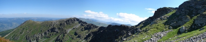
The Rodnian mountains (also called Rodnian Alps or more correct: Rodna mountains, but I prefer to use name: Rodnian ) are placed in the central part of northern Romania. This mountains are rather easy to hike. Because of unique fauna and flora Rodnians are under protection. The area of the National Munti Rodnei Park , in comparison with Polish national parks, lgives the tourist much more freedom. We will find traced routes here, however the keeping the signed routes is not obligatory. You can also camp wherever. For tourists valuing a little bit of comfort, the best accomodation place seems to be town Borsa and placed about 15 km from Borsa - Borsa Turist Centre.
Borsa
is rather large, counting almost 27 thousand citizens (2002 the year ) town, beeing located at the northern slopes of Rodnei mountains.
 Dynamic economic development is very visible here. Numerous buildings and narrow side roads are being built.
The main approach road leads from Sygietu Maramuresz and it is rather good quality road (for comparison - better than many roads in Poland ).
Dynamic economic development is very visible here. Numerous buildings and narrow side roads are being built.
The main approach road leads from Sygietu Maramuresz and it is rather good quality road (for comparison - better than many roads in Poland ).
The touristic base in Borsa is poor ( typically touristic place is Statiunea Borsa, used to be called Complex Touristic Borsa, laid about 15 kilometers from Borsa - many of hotels are there ), although several hotels and guest-house "Borsa Turism" ( very nice place to stay, having the camping field and beeing placed near the highest top Rodnians - Petrosul ) .
There is quite large choice of the various standard restaurants and bars in the town, so everyone can find something for oneself. There is also a supermarket which is open till 10.00 PM.
Romania is often called "the country of contrasts" .
 The example for that is Borsa, where beside steeped in pop-culture centre, noisy cars, You can feel the sentimental
aroma of ancient times. It reflects in cultivating the tradition: elder women wear characteristic clothes:long black,
flowery skirt and scarf on the head. The way of drying the hay is also very interesting (attached photo).
The example for that is Borsa, where beside steeped in pop-culture centre, noisy cars, You can feel the sentimental
aroma of ancient times. It reflects in cultivating the tradition: elder women wear characteristic clothes:long black,
flowery skirt and scarf on the head. The way of drying the hay is also very interesting (attached photo).
Suggested tourist's routes:
duration : approx. 9 hours (to and fro) ; difficulty: easy
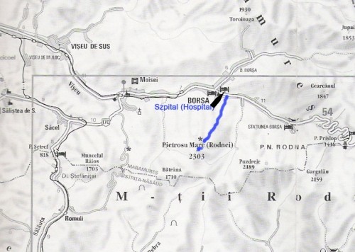
The description of the route: Start place : Borsa centre - main road leads to east in direct of Borsa Turist Centre.
 From the Borsa centre to the entry on the route is a few hundred metres. On the rigth side we will have a characteristic place -
the large hospital. After passing the hospital You have to turn right into narrow side-road. Next, You have to walk ahead
Next, You have to walk ahead to the triangular fork (about 300-400 meters ) where You have to choose middle path.
Here is the start of the route. Our route is marked with blue signs ( vertical blue streak on white background ).
We hike half of hour along buildings.
From the Borsa centre to the entry on the route is a few hundred metres. On the rigth side we will have a characteristic place -
the large hospital. After passing the hospital You have to turn right into narrow side-road. Next, You have to walk ahead
Next, You have to walk ahead to the triangular fork (about 300-400 meters ) where You have to choose middle path.
Here is the start of the route. Our route is marked with blue signs ( vertical blue streak on white background ).
We hike half of hour along buildings.
 Scenery slowly begins to change, there are less and
less houses and more and more trees.
We reach the entry to National Park of Rodnian Mountains. From this place to reach the top of Petrosul You have to hike approx. 4 hours.
The route skirts softly uphill along the forest. In the summer there are lots of raspberries here. During hot and dry weather there is no water here
( just only one very small spring ). We reach
the meteorological station "Iezer" (1785 m n.p.m.). Few minutes walk behind station is small lake, called "Lacul Iezer".
Scenery slowly begins to change, there are less and
less houses and more and more trees.
We reach the entry to National Park of Rodnian Mountains. From this place to reach the top of Petrosul You have to hike approx. 4 hours.
The route skirts softly uphill along the forest. In the summer there are lots of raspberries here. During hot and dry weather there is no water here
( just only one very small spring ). We reach
the meteorological station "Iezer" (1785 m n.p.m.). Few minutes walk behind station is small lake, called "Lacul Iezer".
 From here we have only short (about 1 hour ) traverse on pass and short hike on the top ( we turn right on the pass ).
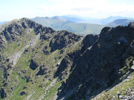
From the top You will see beautiful, breathtaking view: from South on Rodnian Mountains; from North on Maramures Mountains.
When the weather is good The beautiful views stretches from the top of Sr Petrosul:since the noon on Rodniany, from the midnight
on Mountains Marmaroskie. If You'll have luck, it is also possible to see Czarnohora Mountains on Ukraine (by the way, long time
ago here was the board between Poland and Romania). On the top of Perosul is a shelter where You can lurk (f.ex. from the rain ),
but unfortunately inside are plenty litters. The return to Borsa - the same route.
From here we have only short (about 1 hour ) traverse on pass and short hike on the top ( we turn right on the pass ).
From the top You will see beautiful, breathtaking view: from South on Rodnian Mountains; from North on Maramures Mountains.
When the weather is good The beautiful views stretches from the top of Sr Petrosul:since the noon on Rodniany, from the midnight
on Mountains Marmaroskie. If You'll have luck, it is also possible to see Czarnohora Mountains on Ukraine (by the way, long time
ago here was the board between Poland and Romania). On the top of Perosul is a shelter where You can lurk (f.ex. from the rain ),
but unfortunately inside are plenty litters. The return to Borsa - the same route.
duration : approx. 6-7 hours (to and fro; withou approach from Borsa to Statiunea Borsa) ; difficulty: easy
The description of the route: the facility here is a chairlift, which is rather cheap - about 8 lei ,
 On the final chair lift station, You will meet nice guy offering cool bear for 4 lei.
From the station we walk few hunderd meters ahead, till we reach information board. After You have to choose wide path
(our main route on Gargalau pass leads ahead and is marked blue vertical signs ) - a little bit turning right and down - in the direct of highest
Rodnian waterfall - Cailor ( Cascada Cailor ).
On the final chair lift station, You will meet nice guy offering cool bear for 4 lei.
From the station we walk few hunderd meters ahead, till we reach information board. After You have to choose wide path
(our main route on Gargalau pass leads ahead and is marked blue vertical signs ) - a little bit turning right and down - in the direct of highest
Rodnian waterfall - Cailor ( Cascada Cailor ).
 From the waterfall we have two variants : to go back to the information board (approx. 1/2 hour. ),
near which is the fork, or for the practised tourists from from under Cailor, a narrow path leads left and steep up.
In such way we will reach our main blue signed route.
Time of hike from information board to pass Gargalau (1907 m) takes approx. 1,3 hour. From the pass Gargalau on top Gargalau (2159 m) -
the route signed red vertical signs. The return the same route.
From the waterfall we have two variants : to go back to the information board (approx. 1/2 hour. ),
near which is the fork, or for the practised tourists from from under Cailor, a narrow path leads left and steep up.
In such way we will reach our main blue signed route.
Time of hike from information board to pass Gargalau (1907 m) takes approx. 1,3 hour. From the pass Gargalau on top Gargalau (2159 m) -
the route signed red vertical signs. The return the same route.
Photogallery of Rodnian Mountains
(click on below photos to go to galleries)
Rodnian - part 1 (route 1 - Petrosul)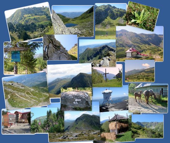
Rodnian - part 2 (route 2 - Gargalau)
Approach and accomodation
Approach from Poland:
There are several variants of the approach to Rodnian mountains. I have heard that the cheapest variant leads through Ukraine, but personally I've choosen variant through Slovakia and Hungary. Our way was the following:
in Poland to Piwniczna town - from there crossing the border by walk and by hitchhike to Stara Lubovna ( honestly speaking not recomended way, because of difficulties with catching hitchhike ) about 16 kilometers in total.
Stara Lubovna - Plaves - by train (leaving about 8.00 PM )
Plaves - through train to Hidasnemeti (Hungarian town ) at 3.30 AM
from Hidasnemeti - at 6.16 AM train to Csenger - small town on Hungary-Romania border ( 4 train changes in: Abujszanto, Szerencs, Nyigershaza, Mateszalka )
in Csenger we was at 4.00 PM - from the town to border is about 7 kilometers walking, it is adviced to have a good map of this area, because of difficulties in communication (people speak Hungarian here...)
From the border we were lucky - we caught hitchhike to Syghiet - a city in the north Romania. From Syghiet at 6.00 AM is a bus to Borsa - our destination place.
 As it was mentioned before, I recommend guest-house "Borsa Turism" with small camping field.
 "Borsa Turism"
is managed by Dutchman, there are: shower, warm water, fire place, benchs and very nice atmosphere.
"Borsa Turism"
is managed by Dutchman, there are: shower, warm water, fire place, benchs and very nice atmosphere.